
Chirripo National Park
Parque Nacional Chirripó
Added by
Anonymous Curator
Reviewed by
Under Review
Last modified by
Julia Trouin
Description
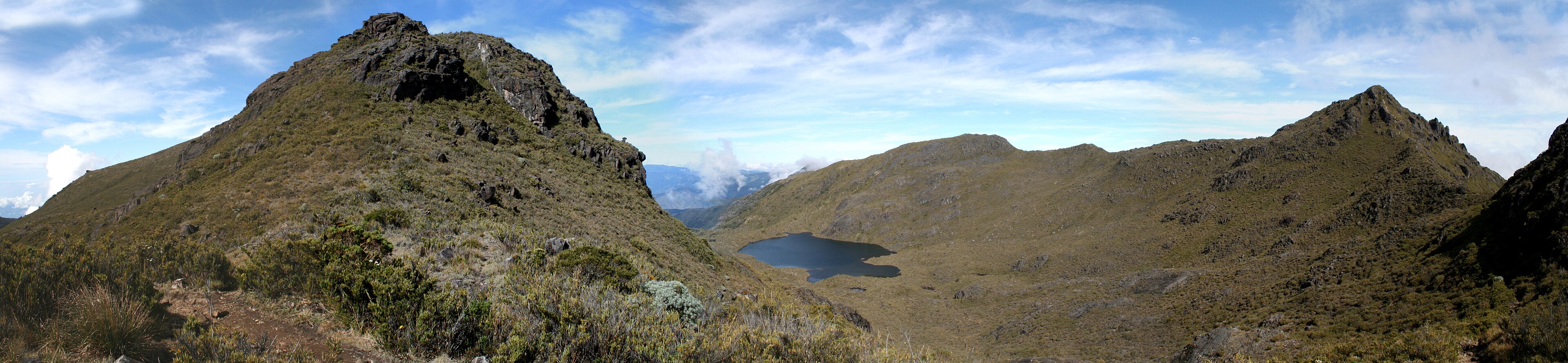
Chirripo National Park protects the highest point in Costa Rica and one of the highest peaks in Central America: Mount Chirripo (3,820 masl). It is a land of dramatic contrasts, home to the country's only vestiges of past glaciations, manifested in beautiful glacial cirques and crystal-clear lagoons. Its beauty lies in the vastness of its paramo and the mysticism of its sunrises, from which, on clear days, both oceans can be seen simultaneously.
ClassificationAdministrative and legal categories that govern how this area is managed and protected.
HistoryHistorical background, founding story, and timeline of legal protection designation.
Created in 1975 to preserve the paramo ecosystem and the water springs of the Talamanca Mountain Range. The name 'Chirripo' comes from the indigenous word meaning 'Land of Eternal Waters,' referring to the abundance of lagoons and rivers originating in its peaks. It is a sacred site for local indigenous cultures and a historical landmark for the community of San Gerardo de Rivas, which has evolved alongside mountain tourism.
Surface AreaTotal surface area subdivided by terrestrial, marine, and buffer zones in hectares.
Entry FeesEntry fee structure for Costa Rican residents and international visitors, in CRC and USD.
Payment is made exclusively online. Lodging and dining services at the Base Crestones lodge are managed by a private concessionaire (Consorcio Aguas Eternas) and require separate reservation and payment.
EcosystemsVegetation communities and ecosystem types present within this protected area.
It features a unique vertical zoning: from majestic centuries-old oak and holm oak forests (cloud forest), through montane rainforest, to the subalpine paramo above 3,000 meters. The paramo is an ecosystem of stunted vegetation, grasses, and shrubs adapted to extreme temperatures, being the most extensive in Costa Rica.
WildlifeNotable fauna and flora documented through scientific surveys and long-term monitoring.
Home to the Baird's tapir, the puma, the forest rabbit, and the endemic Chirripo mouse. In the forested areas, the Quetzal and the Bellbird can be spotted. Especially notable is the presence of high-altitude birds like the volcano junco and several hummingbird species that only inhabit these frigid peaks.
How to Get ThereHow to reach this protected area by road, public bus, boat, or guided tour.
Main access is through the town of San Gerardo de Rivas in Perez Zeledon. From San Jose, it is about a 3.5-hour trip. To reach the summit, a demanding 14.5 km hike to the Base Crestones lodge is required, followed by an additional 5 km to the peak. Excellent physical preparation is required.
ClimateTypical weather patterns, temperature ranges, and seasonal rainfall affecting this location.
Very cold and variable high mountain climate. Summit temperatures can drop to -5°C during the night in the dry season. January to March are the clearest months, ideal for panoramic views.
Visitor RegulationsVisitor rules and restrictions designed to protect the natural heritage of this area.
RESERVATIONS ARE MANDATORY and must be made months in advance via the SINAC website. Entry of single-use plastics, cigarettes, and drones is prohibited. Campfires are strictly forbidden due to the risk of wildfires in the paramo. All waste generated must be removed by the visitor. Mountain gear for low temperatures is vital.
Best Seasons to Visit
Regions
Facilities & ServicesInfrastructure and services available: ranger stations, restrooms, parking, and lodges.
HighlightsDistinctive features and attractions that make this protected area exceptional.
Main ThreatsDocumented pressures reducing the population: habitat loss, hunting, disease, climate change, and invasive species.
- Incendios forestales en el páramo
- Erosión de senderos por alta visitación
- Contaminación de fuentes de agua por desechos humanos
ConservationActive programs and initiatives working to protect and restore this habitat or area.
- Programa de Prevención y Control de Incendios Forestales
- Manejo compartido del albergue con la comunidad local
- Monitoreo biológico del páramo
- Educación ambiental para senderistas