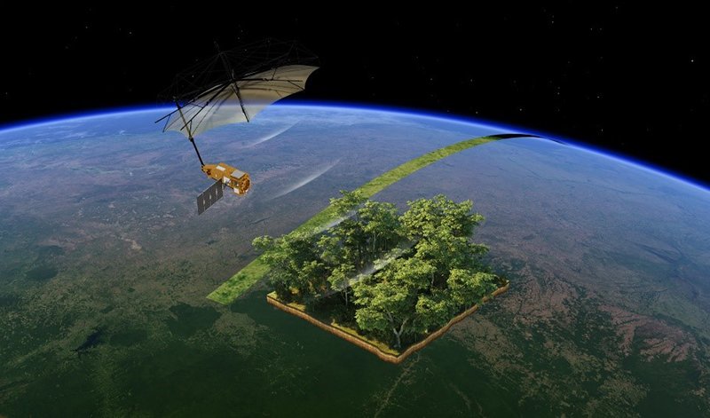
In mid-2025, the European Space Agency (ESA) released the first images from Biomass, a cutting-edge satellite designed to monitor the world’s forests with unparalleled precision. Scientists have described the imagery as “nothing short of spectacular”, highlighting its potential to revolutionize how we track deforestation, coral bleaching, and wildlife habitat changes. For the first time, researchers can peer beneath dense canopies to measure forest biomass and carbon stocks on a global scale.

A Technical Breakthrough
Biomass carries a unique P-band synthetic aperture radar (SAR), the first of its kind in orbit. Unlike optical or shorter-wavelength radars, the P-band can penetrate the thick foliage of tropical rainforests, capturing data about trunks, branches, and woody material that account for most of a forest’s carbon storage.
This innovation means scientists can now map forest structure in three dimensions, producing estimates of carbon with far greater accuracy than before. It is a critical step forward for monitoring how much carbon the world’s forests absorb—and how much is released through degradation and deforestation.


Applications for Forest Monitoring
The satellite’s unprecedented resolution will provide governments and conservationists with real-time insights into:
- Deforestation: detecting illegal logging and subtle forms of degradation invisible to optical satellites.
- Carbon accounting: helping countries meet their reporting obligations under the Paris Agreement by improving estimates of forest carbon stocks.
- Biodiversity monitoring: identifying changes in forest density and fragmentation that affect wildlife corridors.
By targeting hotspots such as the Amazon Basin, the Congo Rainforest, and Southeast Asian jungles, Biomass will shed light on some of the most vulnerable and least studied ecosystems on Earth.

Beyond Forests: Oceans and Wildlife
Although designed for forests, Biomass has shown unexpected potential in other fields. Early images released by ESA include rivers, glaciers, volcanoes, and even coastal zones. Scientists expect that combining Biomass data with ocean color and thermal sensors will enhance monitoring of coral bleaching events, while vegetation cycle data may help predict animal migration routes across savannas and grasslands.
In this way, the satellite is emerging as a multifunctional tool for Earth observation, bridging terrestrial, coastal, and even polar ecosystems.


Policy and Global Impacts
The launch of Biomass is more than a scientific milestone—it is also a policy tool. Its data will feed into:
- IPCC assessments on climate change mitigation.
- National greenhouse gas inventories, improving transparency and accountability.
- Global biodiversity frameworks, including the Kunming–Montreal Global Biodiversity Framework, which calls for halting biodiversity loss by 2030.
Crucially, ESA has committed to open data access, ensuring that scientists and policymakers worldwide, including in developing nations, can use Biomass information for conservation and climate action.
Challenges and Next Steps
Despite its promise, challenges remain. Radar signals can be influenced by soil moisture and topography, and translating raw data into policy-ready information will require significant computing and collaboration. Moreover, political will is essential: even the best data cannot stop deforestation unless governments act decisively on the evidence.
Biomass represents a quantum leap in Earth observation. By providing the most detailed forest carbon maps ever made, it offers humanity a chance to better understand—and protect—the ecosystems we rely on for climate stability, biodiversity, and survival. The satellite reminds us that technology can provide the tools, but only political and societal commitment can turn data into conservation success.